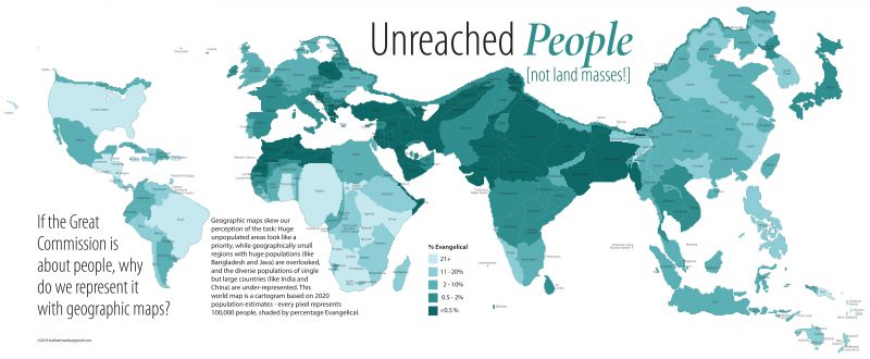
If the great commission is about people, why do we represent it with geographic maps? Geographic maps skew our perception of the task. Huge, unpopulated areas look like a priority, while geographically small regions with huge populations (like Bangladesh and Java) are overlooked, and the diverse populations of single but large countries (like India and China) are under-represented. This world map is a cartogram based on 2020 population estimates. Each pixel represents 100,000 people while the shading indicates the percentage of professing Evangelicals.
Download as PDF Download as Image
<p><img src="https://missio-graphics.s3-us-west-2.amazonaws.com/Volume+7/Unreached-Peoples-Cartogram.png" alt="" width="800" /></p>
<p><a href="https://missionexus.org/unreached-people-not-land-masses"><strong>Unreached People (not land masses!)</strong></a><br />If the great commission is about people, why do we represent it with geographic maps? Geographic maps skew our perception of the task. Huge, unpopulated areas look like a priority, while geographically small regions with huge populations (like Bangladesh and Java) are overlooked, and the diverse populations of single but large countries (like India and China) are under-represented. This world map is a cartogram based on 2020 population estimates. Each pixel represents 100,000 people while the shading indicates the percentage of professing Evangelicals. </p>
Permissions
The representation of this data is copyrighted by Missio Nexus and the information within is used by permission. Missio Nexus grants users the right to reproduce this image digitally and in print for the purpose of educating and engaging audiences with the content. All use must retain the Missio Nexus branding and sponsorship bar located at the bottom of the infographic. Any use of this image in a paid product or service requires permission from Missio Nexus. If you are interested in licensing this image for use in your product or service, please email info@missiographics.com.
